Tectonic geomorphology and earthquake geology of the 1857 reach of the San
Andreas Fault: a new look from Airborne Laser Swath Mapping
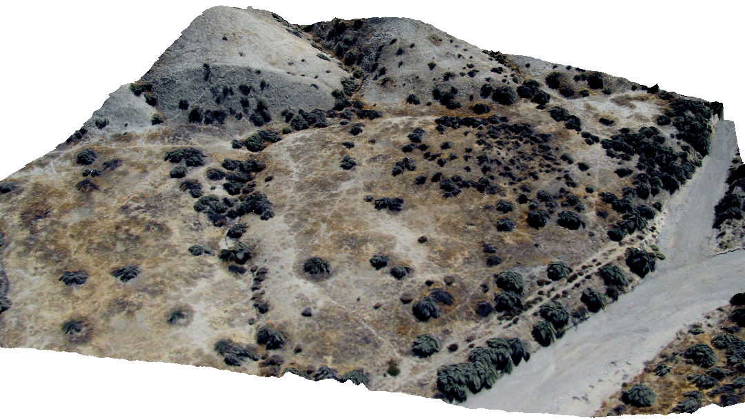 The above image is an aerial photograph (that is rectified to 4 cm pixels) taken from
our balloon system. Brian Campbell and Ramon Arrowsmith took the photo over the San Andreas
Fault in the Carrizo Plain in June, 2006. It was rectified to and draped
over a 25 cm digital elevation model produced from B4 project airborne lidar
survey data gridded using the GEON LiDAR Workflow (GLW)
(http://www.geongrid.org/science/lidar.html). The GLW is a tool for the distribution and processing of LiDAR point cloud data (see: http://lidar.asu.edu/ for more information on this project). Note the stream channel offset 15 meters
along the San Andreas Fault in the middle of the photo.
The above image is an aerial photograph (that is rectified to 4 cm pixels) taken from
our balloon system. Brian Campbell and Ramon Arrowsmith took the photo over the San Andreas
Fault in the Carrizo Plain in June, 2006. It was rectified to and draped
over a 25 cm digital elevation model produced from B4 project airborne lidar
survey data gridded using the GEON LiDAR Workflow (GLW)
(http://www.geongrid.org/science/lidar.html). The GLW is a tool for the distribution and processing of LiDAR point cloud data (see: http://lidar.asu.edu/ for more information on this project). Note the stream channel offset 15 meters
along the San Andreas Fault in the middle of the photo.
This research is supported by the Southern California Earthquake Center and the National Science Foundation through the the GEON project.
SCEC proposal: Arrowsmith_1857.pdf
New Items
Wallace Creek area 50 cm DEM poster for NAGT field trip
Dragon's Back area 50 cm DEM poster for NAGT field trip
Items for NSF nuggets
One-pager on B4 offset studies: http://activetectonics.asu.edu/1857/B4_one-pager.doc
Laboratory exercise focusing on Wallace Creek and the Bidart Fan: http://activetectonics.asu.edu/bidart/2006GVWallaceCreekBidartLab.pdf
Accompanying photographs and figures in powerpoint for Bidart Fan site: http://activetectonics.asu.edu/bidart/BidartPictures.ppt
Recent Abstracts
Arrowsmith, J R., Campbell, B., Crosby, C., Raleigh, D., Tectonic geomorphology and earthquake geology of the 1857 reach of the San Andreas Fault: a new look from Airborne Laser Swath Mapping, Eos Trans. AGU, 87(52), Fall Meet. Suppl., Abstract G53C-0916, 2006. [PDF of poster - 8.4 MB]
We have chosen a number of sites to develop our methodology, all in the Carrizo Plain:
Bidart site
2005 Bidart Balloon Photos
2006 Bidart Balloon Photos
Sites 81, 82, 83 (southern Carrizo Plain)
Sites 81, 82, 83--Balloon
Site 70 area offsets (central Carrizo Plain)
Site 70 area ground photography
Dragon's Back (central Carrizo Plain)
Dragon's Back--Balloon
Dragon's Back ground photography
Wallace Creek area (central Carrizo Plain)
Wallace Creek area--Balloon
ASU Active Tectonics Group
Last modified: October 16, 2010