Paleochannels of the Salt River: Evaluation of recharge potential
A Proposal to the ADWR Year 2000 Water Management Assistance Program
(Augmentation and Conservation Assistance Grants)
November 15, 1999
J Ramón Arrowsmith and James A. Tyburczy
Department of Geology
Arizona State University
Tempe, AZ 85287-1404, U.S.A.
(480) 965-3541 OFFICE (480) 965-8102 FAX
ramon.arrowsmith@asu.edu
Problem
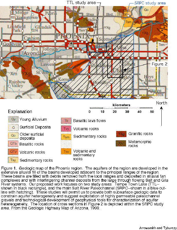
The Phoenix AMA and other portions of the Southwestern US pose interesting problems for groundwater production and for recharge because of the geometry of the aquifers. In the Phoenix basin, the aquifers are predominantly developed in alluvial fan units except for the portions of the basin where the river deposits of the Salt and Gila Rivers and their tributaries dominate (Figure 1). The alluvial upper unit is commonly coarser-grained near the basin margins and contains more fine grained materials in the basin center. The lower alluvial unit is commonly finer grained and may contain evaporites near the center of the basin (Poole, 1986; Montgomery and Harshbarger, 1989). The structure results from the geologic history in which closed basins dominated by alluvial fan and playa landforms and associated deposits have changed in the last few million years to through going river systems that link the formerly closed basins. This transition apparently took place as the active regional extension of the Basin and Range tectonic regime waned and the Colorado Plateau uplifted and the Colorado River system became integrated in the last several million years (e.g., Menges and Pearthree, 1989). These river deposits are significantly different from the alluvial fan units because they come from well developed and regionally extensive river systems and prior to recent history were perennial. They produced large bodies of channel gravel deposits made up of cobbles and boulders that are poorly to well rounded and hard clasts with typical compositions representing the large drainage basin upstream: quartzites, volcanic rocks, granites and other basement rocks (Figure 1). The landscape has changed over the last several million years, and so the position of the principal landforms (the river channels) has not always been constant and positions of the paleo river channels are now commonly covered by alluvial fan gravels. Our hypothesis is that groundwater practices can be optimized with better knowledge of the geometry and hydrologic properties of these channels.
We propose a project to deliver geologic data and inference with regard to the paleochannels of the Salt River in the East and Southeast Valley of Maricopa county and to use shallow geophysical investigations to characterize aquifer heterogeneity (such as paleochannels) and water table variation. The two areas where we will focus this work are in the reach of the current Salt River channel now occupied by Tempe Town Lake (TTL) and in the southeast Valley of Maricopa County where an interesting geologic history for the Salt River channel presents an excellent target for our study. The work of Péwé (1978), and also what is somewhat common knowledge among drillers in the south Tempe, Chandler, and Guadalupe area, indicates that Salt River channel deposits underly alluvial fan deposits from the Queen Creek drainage. These river deposits were apparently deposited when the Salt River flowed southwest to join the Gila River south of South Mountain rather than at its current confluence northwest of the South Mountains sometime in the Pleistocene (Figure 1).
Tools and approach
We propose to use the tools of geology and geophysics to develop better knowledge about the geometry and hydrologic properties of the current and paleo-Salt River channel system. Paleo channel deposits are attractive localities for artificial recharge projects because they are relatively coarse-grained and have low-clay content, and thereforeure yield higher infiltration rates and storage capacity than clay -rich flood/alluvial deposits. Accurate knowledge of the distribution and volume of paleochannel deposits may enable municipalities and utilities to make better decisions concerning locations of recharge projects.
Compilation of geological data to constrain geometry and properties of a paleochannel system
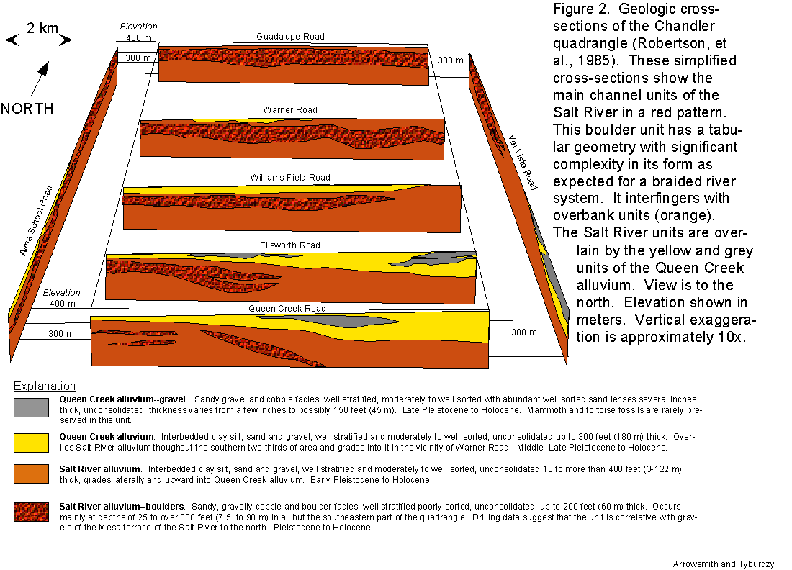
Péwé (1978) argued that in the last few million years, the aggradation of the sediments in the Phoenix region has been a joint effort by the alluvial fans draining the local ranges and the Salt-Gila River system. Studies in the south Tempe, Chandler, and Guadalupe area indicated that Salt River channel deposits underly alluvial fan deposits from the Queen Creek drainage (Figure 2; Péwé, 1978; Robertson, et al., 1985, Robertson, 1986). We hypothesize that this gravel-filled paleochannel presents a significant recharge target because of its enhanced storativity and permeability relative to the more silt-rich and poorly sorted alluvial fan units that surround it. In the first portion of our project, we will improve and extend the determination of the 3 D geometry of this channel and its geologic properties by analysis of well logs, geologic mapping data, and geophysical data collection. Péwé 's work on the Chandler and Guadalupe quadrangles documented the location of the Salt River paleochannel (Figure 2). We will document the 3D position of the boundaries of the channel system as well as its internal structure. Questions that we can address include: what is the overall shape of the paleochannel system? Is it a single U-shaped channel geometry, or do the gravel units have a more shingled depositional relationship with the surrounding alluvial fan units? What is the plan form of the paleochannel? Where did it diverge from the modern Salt river channel? Was it relatively straight or were there many meanders as it conveyed water and sediment to join the Gila River? Where did it join the Gila? What is the approximate volume of the gravels and associated sediments that make up the paleochannel system? How much internal structure is there in the paleochannel? What are the geologic characteristics of the surrounding alluvial fan deposits?
Tasks
We will limit ourselves to the higher quality well log datasets and focus on the shallower subsurface structures (i.e., the Salt River paleochannel in this area).
Environmental geophysics applied to enhanced geometric and hydrologic control and monitoring of active and paleochannel systems
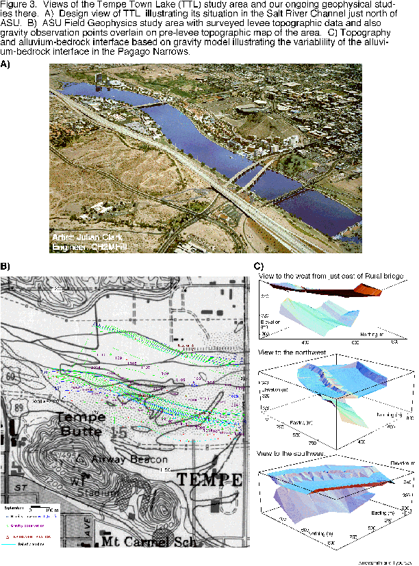
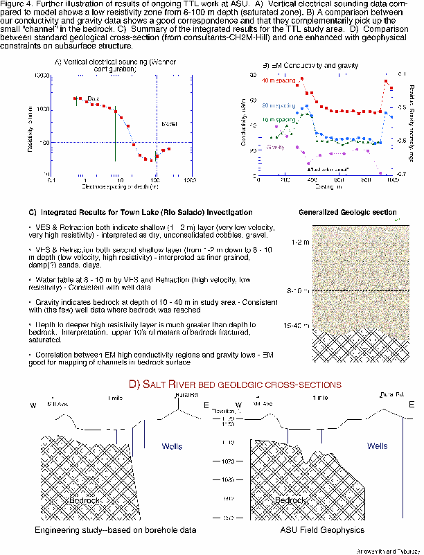
Our previous and ongoing work in the area of the current Salt River channel immediately north of ASU has shown that geophysical tools of gravity, seismic reflection and refraction, and electrical resistivity measurements can significantly augment the description of geologic units and inferences of aquifer structure (Figures 3 and 4; Tyburczy and Arrowsmith, 1997). Figure 3 shows the setting of Tempe Town Lake (TTL) and its situation within the Salt River channel. The second portion of the figure illustrates the detail in the subsurface structure that is evident from our geophysical--in this case, gravity--studies. We have been able to image the interface between the Salt River gravel units and the underlying bedrock in enough clarity to image the paleotopography of the site. The geophysical results that we have obtained demonstrate significant internal consistency as well as illustrate the correlation between geophysical observations and local hydrologic conditions. Figure 4B shows the inverse relationship between electromagnetic conductivity profiles and gravity measurements in the Tempe Town Lake -Papago Narrows reach of the Salt River bed illustrating that in this area ground water flow may be significantly influenced by the detailed topography of shallow bedrock channels and that this topography can be effectively and quickly characterized using electromagnetic profiling methods. Figures 4C and 4D summarize our integrated results for the TTL preliminary investigation. We have been able to identify: two unsaturated layers, the water table, and an implication of saturated fractured bedrock. This level of detail in subsurface constraint should map into significant optimization of water management at TTL and in other similar settings.
Tasks
Our work in the area of TTL indicated that we could use this approach for both defining subsurface properties and also for monitoring subsurface changes. We propose to employ the former in the SRPC (Salt River Paleo Channel) and TTL areas and to continue to test the latter at TTL.
1) We propose to extend and complete our analysis of the Salt River channel subsurface structure in the area of Town Lake, as well as analyze well and microgravity data that we have monitored prior to and since the filling of Tempe Town Lake. These data permit us to evaluate the significance of the aquifer heterogeneity on the hydrologic response of the shallow aquifers as driven by Town Lake recharge and recirculation. In addition, they will provide baseline data on the characteristics of river channel deposits before burial.
2) Determination of the full 3-dimensional form of the paleo channel system will entail preliminary estimation of channel location and boundaries using well logs (and surface geological mapping where possible; see above). Subsequent geophysical investigations using electromagnetic profiling and sounding methods will enable more precise determination of paleochannel boundaries (lateral and vertical). Electromagnetic methods, in particular frequency domain methods of lateral profiling and time domain methods (TEM) for depth sounding (McNeill, 1990; Fitterman and Stewart, 1986), permit relatively rapid determination of subsurface electrical resistivity contrasts. Relatively coarse-grained paleochannel deposits will have a higher resistivity (lower conductivity) than the surrounding clay-rich flood deposits and so represent good electrical targets. At ASU, we possess a Geonics EM-34 electromagnetic conductivity system (frequency domain, for profiling) and a Zonge NanoTEM time domain system for rapid depth sounding. Co-I Tyburczy has over 10 years experience in environmental geophysics in the Phoenix area through his teaching and research activities at ASU.
3) Description and analysis of the groundwater response in the Tempe Town Lake area will employ microgravity measurements in conjunction with well data to determine local and transient directions of ground water flow and interactions (if any) with the surrounding aquifer. We have set up a gravity grid of over 50 sites surrounding Tempe Town Lake and have been taking microgravity readings starting before the Lake began filling and continuing to the present time. Funding provided under this program will enable processing and reduction of these data, correlation with well data, determination of directions of flow during lake filling before the steady state was established, and degree of interaction with the aquifer.
Work Plan
Arrowsmith and Tyburczy have significant experience collaborating on projects. We have taught a course together and worked together as faculty within the ASU Geology Department for more than 4 years. Our course was GLG 416, Field Geophysics at Arizona State University (Spring, 1997): This course provides an introduction to field geophysical methods including refraction seismology, gravity, magnetics, electrical and electromagnetic methods. We are also currently supervising MS student Ken Fergason who has been gathering and analyzing the TTL gravity and groundwater data. We expect to employ a graduate student full time for one year on this project. It will make up the major part of that student's thesis. Such a scenario often adds considerable additional benefits that outweigh training time: the student becomes enfranchised in the project as his or her own and takes responsibility for the high quality of its completion. We will also hire an undergraduate assistant to aid in the data compilation and management. Both students will work out of Arrowsmith's Active Tectonics and Quantitative Structural Geology and Geomorphology laboratory in which adequate space, and computer tools are available (see below). Both Arrowsmith and Tyburczy are committed to this project as an important contribution to regional recharge analysis. We also think that the technological development to be gained from application of the geophysical tools is very important. Each has requested 0.5 month summer salary to cover a portion of their efforts related to the supervision and completion of the project.
References
Burger, H. R., 1992, Exploration Geophysics of the Shallow Subsurface, Englewood Cliffs: Prentice Hall, 489 p.
Fitterman, David V., and Mark T. Stewart, 1986, Transient electromagnetic sounding for groundwater, Geophysics, 51, 995-1005.
McNeill, J. D., 1990, Use of electromagnetic methods for groundwater studies, in Geotechnical and Environmental Geophysics, Volume 1, edited by Stanley H. Ward, pp. 191-218, Society of Exploration Geophysicists, Tulsa, OK.
Menges, C. M., and Pearthree, P. A. 1989. "Late Cenozoic Tectonism in Arizona and its Impact on Regional Landscape Evolution. Geologic Evolution of Arizona, Arizona Geological Society, Digest 17. Edited by J. P Penney and S. J. Reynolds, Arizona Geologic Society, Tucson, AZ. pp. 649-680.
Montgomery, E. L., and J. W. Harshbarger, 1989, in Arizona hydrogeology and water supply, in Geologic Evolution of Arizona, Arizona Geological Society, Digest 17. Edited by J. P Penney and S. J. Reynolds, Arizona Geologic Society, Tucson, AZ. pp. 827-840.
Péwé, T.L., 1978, Terraces of the lower Salt River Valley in relation to the late Cenozoic history of the Phoenix basin, Arizona, in Guidebook to the Geology of Central Arizona: Arizona Bureau of Geology and Mineral Technology Special Paper 2, edited by D. M. Burt and T. L. Péwé, p. 221-226.
Poole, D. R., 1986, Aquifer geology of alluvial basins of Arizona, in T. W. Anderson and A. Ivan Johnson, editors, Regional Aquifer Systems of the United States; Southwest Alluvial Basins of Arizona, AWRA Monograph No. 7, American Water Resources Association, Bethesda, MD. pp. 27-36.
Robertson, J. A., 1986, Environmental Geology of the Chandler Quadrangle, Maricopa County, AZ, part II. Arizona State University Department of Geology M.S. thesis.
Robertson, J. A., Hoyos-Patino, F., and Péwé, T. L., 1985, Geology - Cross-sections, Chandler quadrangle, Maricopa County, AZ.
Tyburczy, J. A., Arrowsmith, J R.: The field geophysics course at Arizona State University: Environmental geophysics in an urban setting, Geological Society of America Abstracts with Programs, 1997 Annual meeting, v. 29, p. 367, 1997.
Active Tectonics, Quantitative Structural Geology and Geomorphology Laboratory and ASU Geology Department Field Geophysics research tools
In this laboratory and related facilities (http://activetectonics.la.asu.edu), available computer hardware tools include 7 Macintosh and PC computers, 2 PC laptop computers for field and laboratory computations, 2 Silicon Graphics Indigo Solid Impact 10000 and Octane Mxi (dual processor) Workstations, a CD-writer, and 5 color printers. Available software (beyond standard Mac/PC drafting and image editing, word-processing, and spreadsheet tools) includes ER Mapper and ERDAS Imagine (including photogrammetric module Orthomax) for analysis of remotely sensed data and digital topographic data), Arc-Info and ArcView for GIS compilation, MatLab for analysis and visualization, and Rockworks for specific geologic graphical productions.
Field tools essential for our projects include 2 Leica-Wild TCM 1100 total stations (consisting of an electronic theodolite and electronic distance meter (EDM)) providing high precision 3 dimensional locations of sighted targets within a few seconds over about 1 km providing a linear accuracy of 3 mm ± 2 ppm and angular accuracy of 3" and recording the data digitally. For data reduction, we use both custom UNIX and Macintosh software and LISCAD--the Leica-Wild surveying and engineering software that is designed to work with these instruments. Geophysical tools and analysis methods in our department include Seismic Refraction (EG&G Model ES-1225 12-channel, Seisview 1.0, RefractModel, RefractSolve (Burger, 1992)); Gravity (LaCoste & Romberg, Model G gravimeter, Grav2D, GravModel RefractSolve (Burger, 1992)); Electrical Resistivity (EDA IP-PLUS, ERModel, ERSolve(Burger, 1992)); Electromagnetic Conductivity (Geonics EM34, Zonge NanoTEM); Magnetics (EG&G Model G-856 Proton Precession Magnetometer, MagModel (Burger, 1992))
|
Budget explanation |
||||
|
Object class categories |
||||
|
Personnel |
||||
|
Jim Tyburczy |
0.5 month summer |
$3,631.00 |
||
|
Ramon Arrowsmith |
0.5 month summer |
$2,879.00 |
||
|
25% Fringe on faculty salaries |
$1,627.50 |
|||
|
Graduate student |
||||
|
50% academic year |
$12,240.00 |
|||
|
100% summer 3 months |
$8,160.00 |
|||
|
Undergraduate assistant |
||||
|
20/hrs per week for 40 weeks |
$8,000.00 |
|||
|
4% Student salary fringe |
$1,136.00 |
|||
|
Total personnel |
$37,673.50 |
|||
|
Travel In state |
||||
|
Per diem in the field |
60 person days (@$10/day) |
$600.00 |
||
|
Mileage for field work in the southeast Valley and to check files at ADWR |
||||
|
500 miles @ $.31/mile |
$155.00 |
|||
|
Total travel |
$755.00 |
|||
|
Supplies |
||||
|
Geophysical Field Supplies, batteries, repairs, misc |
$1,000.00 |
|||
|
Computer use and database maintenance |
$1,000.00 |
|||
|
Total supplies |
$2,000.00 |
|||
|
Total budget (no overhead permitted in program) |
$40,428.50 |
|||
Brief biographical sketches of Principal investigators and graduate student
Ramon Arrowsmith is an Assistant Professor in the Department of Geology at ASU. Arrowsmith has a diverse set of geological interests and expertise in geomorphology, Quaternary geology, structural geology, and active tectonics. My primary interest is in the interaction of climatic, tectonic, and geomorphic processes at the earth's surface. That is investigated with quantitative field observations and analytic and numeric techniques. Current and past research projects include: earthquake geology; theoretical studies of faulting and hillslope development; engineering geologic field methods; Geographic Information Systems; three-dimensional visualization in geology; and Quaternary Geology and desert surface processes. The latter interest has lead to the current focus on landscape development in central Arizona and the role of the integration of the Salt and Gila River systems on piedmont development and the geometry of sedimentary packages in these settings. Arrowsmith received a BA from Whittier College in 1989 and a Ph.D. from Stanford University in 1995 before coming directly to ASU.
James A. Tyburczy is a Professor in the Department of Geology at ASU. He leads a major research program in the field of mineral physics and experimentation on the physical properties of earth materials under extreme conditions. In addition, Tyburczy has developed and run the Field Geophysics (GLG 416) course at ASU for over 10 years, and this has lead to an interest in environmental geophysics and applied problems. The course emphasizes urban environmental geophysics through the use of gravity, seismic, magnetic and electrical techniques and through a very hands-on, problem solving teaching methodology. Outgrowths from this interest include hydrogeological studies of the Tempe Town Lake (Rio Salado) Project, effects of the development of the dry Salt River bed through Tempe and Phoenix, and groundwater hydrogeology and recharge in the Phoenix AMA. This work emphasizes integration of diverse data sets and development of joint interpretations based on results of multiple methods including strong geological controls. Tyburczy received his BA from Whitman College in 1974, his Ph.D. from the University of Oregon in 1983, and served as a post-doctoral fellow at the California Institute of Technology before coming to ASU in 1986.
Ken Fergason is a MS candidate in the Geology Department at ASU. He has a BS in Engineering Geology from Texas A&M (1998). Ken has worked in collaboration along with Arrowsmith and Tyburczy with Maurice Tatlow, Frank Corkhill, and Mike Winn of the ADWR Hydrology Division in the application of microgravity monitoring to the investigation of groundwater changes at Tempe Town Lake. The proposed work will make up the bulk of the thesis of Fergason.