Images of active tectonics from the northern Pamirs
Reference:
Arrowsmith, J R., and Strecker, M. R., Seismotectonic range-front segmentation and mountain-belt growth in the Pamir-Alai region, Kyrgyzstan (India-Eurasia collision zone), Geological Society of America Bulletin, 111, 11, 1,665--1,683, 1999.

tiff format
Location in Asia on GTOPO30 1 km digital topography.

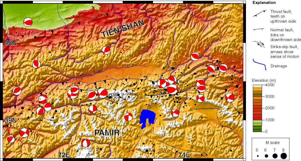
Topography and seismicity in the Alai region. The seismicity shows predominantly thrust and strike-slip events around the outer arc of the Main Pamir Thrust (major fault with teeth on hanging wall. Focal mechanisms are from the Harvard CMT catalog while the black dots are from the Council of the National Seismic System with events from 1963 to the present. Digital topography is the GTOPO30 1 km dataset.


Perspective views of Landsat TM draped on DEM, looking toward the southeast (above) and west (below) over the Trans Alai Mountains. The low relief surface is the Alai Valley which is separated from the Pamir Plateau (where the extensional basin of Lake Karakul is evident) by the Trans Alai Range at whose northern foot is the active Main Pamir thrust. Digital topography is the GTOPO30 1 km dataset. These images are from Sean McManus (McManus, 1998).
Sean McManus, Digital Elevation Model Analysis Applied to Active Tectonic Study in Central Asia, M.S. thesis, 86 pp., Arizona State University, December 1998.

tiff format
View upstream (south) in the Minjar River drainage showing a spectacular flight of fluvial terraces and the high topography of the Trans Alai Range, Kyrgyzstan. The highest portions of the range are composed of a thrust sheet of Paleozoic rocks over Cretaceous rocks (grey rocks in the center of the field of view), whihc are in turn thrust over Neogene conglomerates, evident in the right middle of the photograph. The terraces slope gently upstream. They are situated on the hanging wall of the major south dipping range bounding thrust fault (Main Pamir Thrust) and do not show any evidence of deformation indicating that the deformation is localized at the range front (4 km behind the viewer). The distance to the end of the terraces from the viewpoint is about 3 km. This is the original version of the cover photograph for the GSA Bulletin issue in which Arrowsmith and Strecker, 1999 appeared.

tiff format
photoshop 6 format
Photo taken from the north side of the Alai Valley looking southeast at the Trans Alai Range and Peak Lenin (7134 m). The base of the range front is 3000 m elevation. The range is composed of a series of thrust sheets that place progressively older rocks over younger with Paleozoic rocks making up the higher portions of the range. Cretaceous rocks are in the middle portion, and Paleogene-Neogene are in the foothills, with the active thrust at the base of the range placing Tertiary to Pleistocene conglomerates over Holocene rocks. This is the original version of figure 5 in Arrowsmith and Strecker, 1999.

tiff format
Minjar fault scarp and wedge of colluvial material overridden by thrust slip along the central section of the Main Pamir Thrust. Note also the break in slope coincident with the offset in the exposure. This view provides evidence for the most recent surface rupturing earthquake along the range front and indicates that it was sufficently large to offset the surface by about 1.5 m. View toward the west. Boy on left is 1.4 m tall. This is the original version of figure 13 in Arrowsmith and Strecker, 1999.

tiff format
View of Syrinadjar fault zone and scarp along the central section of the Main Pamir Thrust. This photograph was taken from the west side of the Syrindajar River looking toward the east-southeast, showing the fault scarp that has developed in an early to middle Holocene terrace surface and the river cut that exposed the fault zone. This 18 m high scarp is apparently less than about 6 ka, suggesting a slip rate along the 30 south dipping thrust fault of more than 6 mm/yr. Note the person for scale in the channel bottom and vehicle and tents in background at scarp base. This is the original version of figure 10A in Arrowsmith and Strecker, 1999.

tiff format
View south in the Tashkungey drainage just north of Peak Lenin (high mountain to left) and Peak Derzhinskey (to right). The valley shows two main moraine and inset terrace sequences. The red rocks in the middle elevations are mostly Paleogene sediments that were probably deposited in a broad shallow basin that was continuous between the Tadjik Basin to the west and the Tarim Basin to the east and has been completely closed in this area due to convergence of the Pamir northward to the Tien Shan. High snow-covered portions of the range are Cretaceous and older rocks in a series of north-vergent thrust sheets. The small light objects are approximatley 5 meter wide yurts (tents).
Pages maintained by Ramón Arrowsmith, Department of Geological Sciences, Arizona State University
Last modified 9 September, 2001