Laura Musacchio and J Ramón
Arrowsmith
Research question: To what extent have geological patterns shaped the location and boundaries of the public open space system of Phoenix?
Boundary for project: CAP-LTER
I agree with the extent being the CP-LTER, but also that we should focus on one or two areas (White Tanks and/or UnionHills).
Project ideas:
Historical perspective - geology, open space
I am not exactly sure what you have in mind here.
But one thing that comes to mind is that we might be able to take historic data for land use change and consider those transitions in terms of geological parameters such as elevation, slope, curvature, landform, geologic unit. With such a dataset of spatial and temporal transition sensitivities, one might be able to do some empirical modeling for future development and thus consider various scenarios and the response of the development scenario to the geological template.
Spatial mapping perspective - geology vs. public open space patterns
Right. The mantra we have been developing is that the geological pattern that geologists define while mapping describes the distribution of materials and their connectivity, as well as indicates the types and magnitudes of surface processes in operation on those surfaces. For example, a stream channel map unit will be defined by its topography and gravel fill, and we can anticipate that it will occasionally be transporting water and sediment and that transport may also be associated with erosion and deposition (and lateral and vertical motion of the channel). Or, we can talk about piedmont units that we can demonstrate are low relief, dominated only by animal and plant induced disturbances and occasionally runoff and have been stable for 10s to 100s of thousands of years. We hypothesize that because of the fundamental control of the geology on material, process, and elevation distribution, the pattern of the geologic units provides a template for subsequent ecological and planning processes and thus their patterns.
Landscape ecological perspective - grain, extent, connectivity, spatial heterogeneity, process
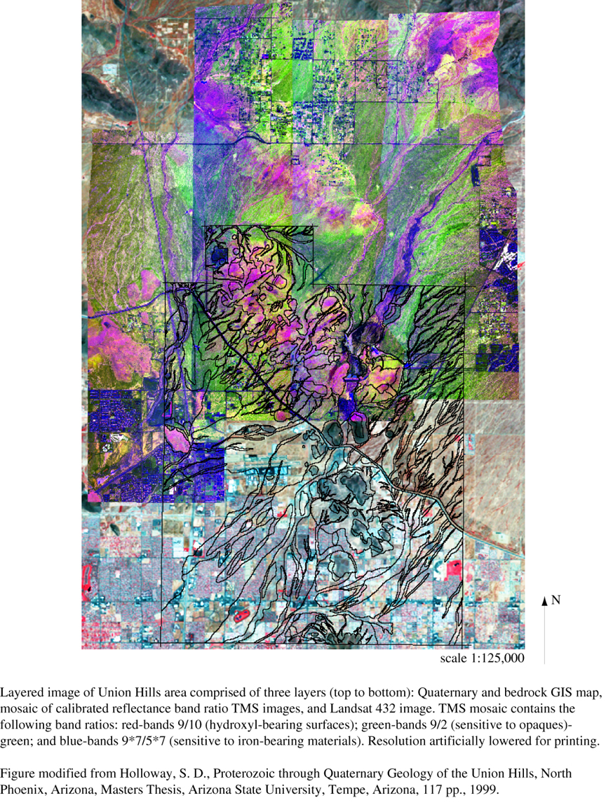
We might want to take a figure like the one below, and show the patterns about which we speak.
In the north Phoenix area, we can see in this layered image the Landsat and airborne TMS data overlain by a geologic map coverage that outlines the principal bedrock and Quaternary (last 1.8 million years) geologic units. The geology as well as the landforms illustrated in the imagery impose a grain on the region that contrasts with the patterns of the development as shown in the lower portion of the images.
To what degree has that development been influenced
by the landforms and geology? To what degree is the geology considered
in planning? How could planning decisions been influenced by better knowledge
of the geology? Optimization of development expense ($/geologic unit),
development value ($/viewshed geology type), etc. could be done with the
basic data of the geology.
Future research/gaps in knowledge
Here we should say that this study will have
applications for the applied aspect of the careful consideration of future
growth of Phoenix and other cities (especially those in semi-arid environments),
as well as the basic aspect of the consideration of urban and natural processes
in their geologic and ecological contexts. Thus, this case study
should lead to regional work with the cities as well as funding opportunities
as initiatives in urban ecology present themselves.