
|
Figure C.1. Shaded relief map of central California showing the situation of the Carrizo Plain in the Coast Ranges. The orange line shows the surface trace of the SAF, and is thicker along the portion that is inferred to have ruptured in the 1857 earthquake [Sieh, 1978c]. TR is Temblor Range; CR is Caliente Range; CV is Cuyama Valley; LP is La Panza Range; SV is Salinas Valley; CP is Cajón Pass; TP is Tejón Pass; W is Wrightwood. Original relief map is from Relief map of the world: cylindrical projection; elevation data from ETOPO5 dataset; by Ray Sterner, Johns Hopkins University Applied Physics Laboratory. |
|
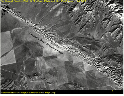
Figure C.2. Panchromatic SPOT image (courtesy of SPOT Image Corp.) of the southeastern Carrizo Plain illustrating the geography, physiography, and geomorphology of the Caliente Range foothills (at the bottom); the southeastern Carrizo Plain (center); and the Elkhorn Scarpdefined in the northwest by the pressure ridges, including the Dragon's Back, and in the southeast by the southwest side of the Elkhorn Hills (northeast of the SAF, NEH is northern Elkhorn Hills, and SEH is Southern Elkhorn Hills). The Elkhorn Plain separates the Elkhorn Hills from the Temblor Range (at the top right). |
produced distinctive rock art (e. g., Painted Rock), and probably hunted the many animals attracted to the Carrizo Plain in wet times for its Soda Lake and gathered nuts and other vegetation in the surrounding mountains [Cawley, 1962]. The early aborigine culture that flourished in the Carrizo Plain was surely affected by great earthquakes, and may have even departed as the result of one (further research in the native descriptions of great earthquakes in this area could be interesting, similar research has been done for the coastal Indians of northwest California and their oral records of Cascadia subduction zone earthquakes). Spaniards came through the area in the 1700s and named the area "Carrizo" after the lush reeds growing there [Cawley, 1962].
C.2. Early geologic Investigations of the "San Andreas Rift" and the Elkhorn Hills
a line or narrow zone characterized by peculiar geomorphic features, referable either directly to the modern deformation of the surface of the ground or to erosion controlled by the lines upon which such deformation has taken place.... The later movements on this line have given rise to minor features which subaerial and stream erosion have not yet obliterated, and it is these minor features chiefly which have attracted attention to the Rift by reason of their more striking contrast with more common geomorphic forms due to erosion. These minor features are chiefly low scarps and troughs bounded on one or both sides by low, abrupt ridges in which frequently lie ponds or swamps of quite small extent [Lawson and others, 1908, p. 25 - 26, V. 1].
[In the northwestern end of the Carrizo Plain (near Simmler),] Here the width of the broken country is much greater than usual, being nearly a mile. A number of lines of displacement can be distinguished; some nearly obliterated, others comparatively fresh. This is a region of light rainfall and gentle, grass-covered slopes, presenting just such conditions as would preserve for hundreds of years the effects of moderate displacements. The Rift zone continues to be traceable along the western base of the Temblor Range, finally passing out onto the gently rolling surface of the eastern edge of the Carissa Plain. Broken and irregular slopes, cut-off ridges, blocked ravines, and hollows which are white with alkaline deposits from standing water mark the Rift. Carissa Plain has a length of about 30 miles. About halfway, the rift begins to be marked by a low and nearly obliterated bluff along its northeastern wall. This is at first little more than a succession of ridges or hills cut off on the side next to the level plains. These detached ridges finally become connected in a regular line of hills with a steep but deeply dissected slope toward the southwest, and long gentle slopes toward the northeast. This ridge is clearly a fault block, and now separates the southeastern arm of Carissa Plain from Elkhorn Plain. It probably originated during some earlier movements along the Rift; in fact, it is reasonable to suppose that it is of the same age as other important scarps which mark the Rift thruout its whole course, and which came into existence as a result of some mighty movement opening the earth for several hundred miles. Except for one slight bend, the ridge which we have been describing follows a straight course toward the southeast for a distance of nearly 20 miles, finally blending in a much larger mountain-like elevation. This has a height of perhaps 500 feet above the sink at its southern base. Its deeply dissected front is in line with the front of the ridge already described and the two appear to have originated together. The steeper face is deeply sculptured into gullies and sharp ridges, while the back slopes off gently toward the southern end of Elkhorn Plain. Plainly visible along the steep front of the line of hills are the lesser ridges and hollows produced during the last violent earthquake in this region, probably in 1857 (p. 41, V. 1, [Lawson and others, 1908]).
This clear and interesting description of the pressure ridges along the Elkhorn Scarp (³...deeply dissected slope toward the southwest, and long gentle slopes toward the northeast. This ridge is clearly a fault block, and now separates the southeastern arm of Carissa Plain from Elkhorn Plain²), and its coalescence into the Northern and Southern Elkhorn Hills (not yet so named; ³Except for one slight bend, the ridge which we have been describing follows a straight course toward the southeast for a distance of nearly 20 miles, finally blending in a much larger mountain-like elevation.² These features have been investigated in detail by Arrowsmith, 1991b; Arrowsmith, 1991a; Rhodes and Arrowsmith, 1991; Arrowsmith, 1992a; Arrowsmith, 1992b; Arrowsmith and Rhodes, 1992 and Chapter 4 of this Dissertation (Figure C.2). The conclusions of Fairbanks regarding the origin of these features are impressive in that, even in 1906 (and perhaps a realization from the 1906 earthquake), he recognized the scale of and suggested the nature of the physical deformation associated with the San Andreas Fault.
The topography produced by the latest movements in this region is unique and interesting. Low ridges on both or one side of elongated depressions, sunken areas in flat land, and great furrows along hill slopes are some of the evidences of the fracturing which occurred, as near as can be determined, in 1857. Definite evidence of horizontal movement has been found in the region, at one point of over 400 feet [Wallace Creek]. Actual measurements of between 8 and 20 feet of such displacement were made at the time of the San Francisco earthquake of 1906, which occurred at and near the northwestern end of the same zone of faulting. These latest faults are mostly of the normal type and are usually parallel or convergent at very low angles. Elkhorn Scarp is the most striking topographic evidence of the action of the San Andreas faulting. It is undoubtedly due to the dropping down of the Carrizo Plain or the elevation of the Elkhorn Valley about 200 feet. From the upper end of this scarp the fault zone extends into the Mount Pinos Mountains and thence into the San Gabriel and San Bernardino ranges.
The discussion of the Elkhorn Scarp¹s striking aspect followed by the description of its continuation to the south (into what is now called the Big Bend), reflects the possible structural association of the Elkhorn Hills and the beginning of the Big Bend. The Elkhorn Scarp is composed of several pressure ridges in the northwest, and a steep and incised southwest facing scarp to the southeast (see Chapter 4 and Figure C.2).
The Paso Robles formation was deposited as alluvial fill throughout Salinas Valley, and derived from the neighboring ranges as they rose. As the valley area became filled, the source areas were eventually reduced to low relief, as indicated by the old erosion surface on the crests of the Temblor and Caliente Ranges [see Galehouse, 1967 for details on the Paso Robles formation]. The Paso Robles formation was deposited when Carrizo Plain was being carved out by a major stream that must have meandered and flowed northwestward, as suggested by several steep-sided crescent-shaped erosional re-entrants carved into the hills at its southwestern border near Soda Lake. This episode was followed by uplift of the entire region by more than 1,000 feet. This uplift resulted in severe dissection by the San Juan drainage system, and in abandonment of Carrizo Plain by the stream that once flowed through it. The regional uplift was accompanied by lateral movement on the rift zone and associated local deformation. These movements formed the Elkhorn Hills, in which the Paso Robles gravel became anticlinally arched on the northeast side; and formed the present alignment of scarps, ridges, and trenches that extend northwesterly to and beyond Cholame Valley. Throughout this area stream washes that drain southwesterly from the Temblor Range are offset northwestward as they cross the fault, some as much as half a mile. These features clearly show that the north-eastern block on the rift zone has been shifting south-eastward relative to the southwestern block. In many places adjacent to and near the rift zone the alluvial gravel of the Paso Robles formation has been compressed into numerous minor domed folds with axes that trend slightly more west than does the rift zone. These compressive features no doubt are also the effect of right lateral distortion of the ground near the rift zone [Dibblee, 1962, p. 12].
The Elkhorn Hills are an elongate upwarp, the crest of which is broken into a series of grabens. Some of the grabens have a sigmoid pattern..., suggestive of broad strike-slip strain. The upwarp may have formed when gouge and brecciated material in a fault zone approximately 2 km wide was squeezed upward in a semi-plastic state by regional stresses normal to the fault zone. The overlying, poorly consolidated, Paso Robles formation, once upraised, has slid laterally, producing large areas of landslides on the flanks of the upwarp and grabens at the crest. The grabens were later bowed by right-lateral strain into the sigmoid patterns now present. Large landslide blocks moved southwest, crossed the most active strand of the San Andreas fault, and were then transported northwestward from their original position ([Wallace, 1975, p. 244]; Figure C.2).
Near the southern end of the Carrizo Plain, the San Andreas fault is the southwestern boundary of the 15-km-long Elkhorn Hills.... Most of the northeastern base of the Elkhorn Hills displays scarps indicative of thrust faulting. Thus the Elkhorn Hills appear to constitute a crustal block that has risen between the San Andreas and the thrust fault, herein named the Elkhorn fault. Large linear grabens and closed depressions within the Elkhorn Hills indicate that a great deal of internal deformation has taken place also. Small scarps in Holocene (?) alluvial deposits along the Elkhorn fault are so fresh as to suggest that they may have formed during the 1857 event.... Alluviation since this event has obscured any clear indication of a lateral slip component on this fault. However, it seems very unlikely that the latest movement on the sinuous, very low-angle thrust fault could have included more than 1 m of lateral slip. Many of the faults in the Elkhorn Hills also display relatively young scarps and, in several closed depressions, many fissures and sinkholes related to "piping" are demonstrably historic. The evidence for ongoing deformation of the Elkhorn Hills suggests that substantial lateral deformation within the hills may have accompanied the 1857 event. Thus, the change form 9 to 7 m of lateral slip in this region may be less abrupt when measured across the entire zone of deformation. ([Sieh, 1978c, p. 1445]; Figure C.2).
Trenching and geomorphologic mapping reveal that the welt [the Elkhorn Hills] is a product of crustal shortening which has been accomplished primarily by folding and reverse faulting. These structures have developed sequentially northwestward from the San Andreas Fault and suggest systematic enlargement of the landform normal to the fault. The most recent episodes of shortening are expressed at the margin of the hills where a young fault cuts active alluvial fans. Discrete faulting events are recorded by colluvial wedges in the fan deposits adjacent to the fault scarp. Equivalent amounts of separation between the colluvial wedges indicate that the two most recent seismic events have comparable displacements and, if the fan surface is aggrading uniformly, similar recurrence intervals. Similar but older low angle reverse faults are inferred to exist within the Elkhorn Hills. Gentle monoclines dip away from each reverse fault and towards the San Andreas Fault. Relative ages of the structures were determined by comparing drainage development, slope angle, and alluvial fan size associated in the lithologically uniform hills. The style of deformation and its sequential development are consistent with shortening perpendicular to the San Andreas Fault elsewhere along the "Big Bend" [Thomas and Sieh, 1981]; Figure C.2).
C.3. Historic and Paleo-seismicity
|
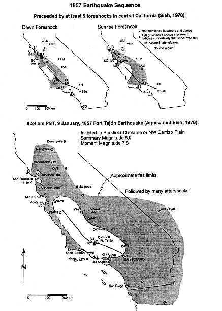
Figure C.3. Felt intensity distributions for the 1857 earthquake sequence showing the two most prominent foreshocks [Sieh, 1978a], and the mainshock: the Fort Tejón Earthquake [Agnew and Sieh, 1978]. |
a transitional reach with both creep and earthquake events and 1857-type events may be triggered by such a moderate earthquake [Sieh, 1978c; Sieh and Jahns, 1984].
|
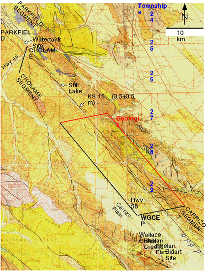
Figure C.4. Important sites around the northern portion of the Carrizo Plain and the Cholame segment of the San Andreas Fault. The definition of the segmentation of the SAF by WGCEP, 1988. That for the Cholame segment is illustrated along with segment boundaries suggested by geologic evidence: the 1857 slip increased by a few meters and the surface trace bends in the area of Bitterwater Canyon. The Watertank site is a paleoseismic site [Sims, 1987]. Still Lake is a site that has been reconnoitered and is recommended for paleoseismic investigation. Note that it is 73 km between the existing paleoseismic sites in the Carrizo Plain and the Watertank site. KS 15 and the associated number refers to offset channel #15 from Sieh, 1978c and L&S '89 refers to the higher offset determined for the same channel by Lienkaemper and Sturm, 1989. James E. Freeman surveyed township boundaries from township 24 south in 1855 and 1856, and Grant and Donnellan, 1994 recovered original monuments from that survey spanning the SAF in the Carrizo Plain near Wallace Creek. The background is from the 1:250,000 scale San Luis Obispo and Bakersfield sheets of the state geologic map. |
|
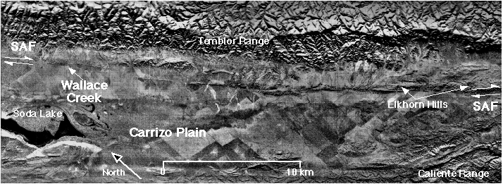
Figure C.5. Side Looking Airborne Radar image of the Carrizo Plain area. Look Direction is northeast. The rugged topography of the Temblor Range along the north side of the image is a contrast to the flatter Carrizo Plain. The patchwork texture of the Carrizo Plain results from variable grazing and farming practices on different properties. Soda Lake is the lowest portion of the Carrizo Plain (~1900' elevation). The SAF follows the southwestern foothills of the Temblor Range. Local relief along the SAF and a more westerly SAF strike increase toward the southeast. In the area of Wallace Creek in the northwest, little local relief is evident and Recent fault activity has been confined to dominantly strike-slip along a narrow fault zone. Toward the southeast in the Elkhorn Hills, on the other hand, local relief and secondary fault activity increase, possibly the result of increased contraction across the SAF zone caused by a more westerly SAF strike as it enters the Big Bend. |
|
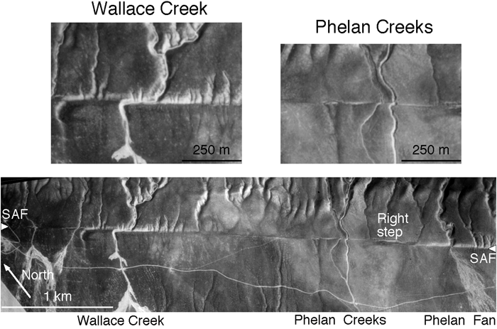
Figure C.6. Aerial photograph of the SAF zone in the central Carrizo Plain. The locations of the important landforms and paleoseismic sites of Wallace Creek [Wallace, 1968; Sieh and Jahns, 1984]; Phelan Creeks [Sims et al., 1989; Sims et al., 1993; Sims et al., 1994]; and Phelan Fan [Grant and Sieh, 1993] are shown. The trace of the SAF is indicated by the triangles on the lower photo. Note the en échelon, right stepping pattern of the SAF in this area. Local extension associated with a right step in the southeastern portion of the lower photograph has produced a small graben [Sims et al., 1990]. The upper two photos are blow-ups to show the detail of Wallace Creek and Phelan Creeks. Photograph courtesy of the Fairchild Aerial Photography Collection at Whittier College. Original photograph scale 1:24,000; photograph date 26 February, 1936. |
extensive paleoseismic investigation of 23 trenches, Sims et al., 1989; Sims, 1994; and Sims et al., 1994 developed a chronology for the offset of the three sets of downstream channels at Phelan Creeks and determined a slip rate of 35.1 ± 2.6 mm/yr from the 238 ± 15 m offset of a channel system incised before 6778 ± 62 CAL B.P. For a channel incised a few decades after 3,764 ± 45 yr CAL BP or 3335 ± 129 yr CAL B.P. and offset 122.2 ± 1.5 m, slip rates of 32.5±2.1 mm/yr and 36.4±5.0 mm/yr are determined. Grant and Donnellan, 1994 recalculated the 14C dates from Sieh and Jahns, 1984 to determine a revised late Holocene slip rate of 33 ± 3 mm/yr. Clearly, these data are similar to that of Sieh and Jahns, 1984, and an average late Holocene slip rate of ~33 mm/yr may be assumed.
C.3.3. Previous eventsslip and timing
|
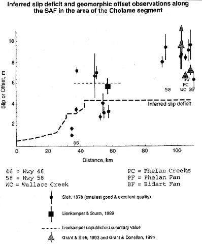
Figure C.7. Inferred slip deficit and geomorphic offset observations along the SAF in the area of the Cholame segment. The bold dashed line shows the inferred historic slip deficit assuming that all slip was released in the 1857 earthquake. The northern portion is constrained by observations of historic offset by Lienkaemper and Prescott, 1989, and the southern by assuming that the deficit accumulates at the long term slip rate of 33 mm/yr. Geomorphic observations are shown with error bars: circles are from Sieh, 1978c; square is from Lienkaemper and Sturm, 1989; the thin dashed line is the summary value from J. Lienkamper, unpublished field notes, 1987-1995; and the triangles show the results of Grant and Sieh, 1993; Grant and Sieh, 1994. The result from Grant and Donnellan, 1994 was 11 ± 2.5 m over a one mile aperture spanning th SAF. |
|
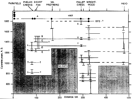
Figure C.8. Inferred temporal and spatial distribution of surface rupturing earthquakes along the SAF in central and southern California. (modified from Grant and Sieh, 1994 by adding inferences from Sims et al., 1989; Sims, 1994; Sims et al., 1994). Dots indicate ages of events from historic records. Vertical bars indicate possible ages within 1 s (Phelan Creeks), and 95% confidence (all others) for pre-historic events. Letters refer to events defined in individual studies. Horizontal lines indicate possible correlations of events between sites; dashes and question marks indicate greater doubt. Phelan Creeks data is from Sims et al., 1989; Sims, 1994; Sims et al., 1994; Bidart Fan data is from Grant and Sieh, 1994; and Wrightwood data is from Fumal et al., 1993; Weldon, 1991. All other data is from published summaries compiled in WGCEP, 1988. |
example, 9 m of slip would imply 257 year recurrence interval; [Sieh and Jahns, 1984]). Paleoseismologic studies of offset stratigraphy and landforms have provided data on the activity and applicability of simplistic recurrence models, as well as the spatial distribution of large events on the Carrizo Plain. The quality and distribution of the paleoseismologic data are dependent on the fortuity of preservation, as well as the skill and technology of interpretation. In this regard, the data are limited to several sites and have been reinterpreted. As more data becomes available, the picture of slip events along the SAF will no doubt be reinterpreted.
C.4. Slip deficit along the Cholame segment and potential for rupture of M 7 earthquakes
C.5. Acknowledgments
C.6. References
The Working Group on California Earthquake Probabilities (WGCEP), Probabilities of large earthquakes occurring in California along the San Andreas fault; USGS Open File Report 88-398, 1988.Agnew, D. C. and K. E. Sieh, A documentary study of the felt effects of the great California earthquake of 1857, Bulletin of the Seismological Society of America, 68, 1717-1729, 1978.
Allen, C. R., The tectonic environments of seismically active and inactive areas along the San Andreas Fault system, in Proceedings of conference on geologic problems of San Andreas fault system, (edited by W. R. Dickinson and A. Grantz), Stanford University Publications in the Geological Sciences, 70-82, 1968.
Antonellini, M., R. Arrowsmith, A. Aydin, P. P. Christiansen, M. Cooke, K. Cruikshank, Y. Du and H. Wu, Complex surface rupture associated with the North Emerson Lake fault zone, caused by the 1992 Landers, CA earthquake: results of detailed mapping, EOS Transactions AGU, 73, 362, 1992.
Arnold, R. and H. R. Johnson, Preliminary report on the McKittrick-Sunset oil region, Kern and San Luis Obispo counties, California, U. S. Geological Survey Bulletin 406, 1910.
Arrowsmith, J. R., Coupled tectonic deformation and geomorphic degradation along the San Andreas Fault system, PhD. Dissertation thesis, Stanford University, 1995.
Arrowsmith, R., Coupled tectonic deformation and landform development along the San Andreas fault, in Proceedings of The Rock Fracture Project, (edited by D. D. Pollard and A. Aydin), The Rock Fracture Project, II, H-1 to H-7, 1991a.
Arrowsmith, R., The Northern Elkhorn Hills: A 2 km wide deformation zone near the Big Bend of the San Andreas fault, Geological Society of America Abstracts with Programs, 23, 4, 1991b.
Arrowsmith, R., Fault zone structure and geomorphology along the San Andreas fault, in Proceedings of The Rock Fracture Project, (edited by D. D. Pollard and A. Aydin), The Rock Fracture Project, III, J-1 to J-7, 1992a.
Arrowsmith, R., Progressive deformation and degradation along the northern portion of the Big Bend of the San Andreas fault, Geological Society of America Abstracts with Programs, 24, A147, 1992b.
Arrowsmith, R. and D. D. Rhodes, Kinematics, structure, and degradation of pressure ridges along the San Andreas fault in the Carrizo Plain, San Luis Obispo County, California, Geological Society of America Abstracts with Programs, 24, 3, 1992.
Arrowsmith, R. and D. D. Rhodes, Original forms and initial modifications of the Galway Lake Road scarp formed along the Emerson Fault during the June 28, 1992 Landers, California earthquake, Bulletin of the Seismological Society of America Special Issue on the Landers Earthquake Sequence, 84, 511-527, 1994.
Cawley, J. J., Aborigines of the Carrizo Plain, in Guidebook: geology of Carrizo Plains and San Andreas fault, (edited by O. Hackell), San Joaquin Geological Society and Pacific section, AAPG and SEPM, 36, 1962.
Dibblee, T. W., Displacements on the San Andreas rift zone and related structures in Carrizo Plain and vicinity, in Guidebook: geology of Carrizo Plains and San Andreas fault, (edited by O. Hackell), San Joaquin Geological Society and Pacific Section, AAPG and SEPM, 5-12, 1962.
Dibblee, T. W., Regional geologic map of the San Andreas and related faults in Carrizo Plain, Temblor, Caliente, and La Panza ranges and vicinity, California, United States Geological Survey Miscellaneous Geologic Investigations Map I-757, 1973.
Ellsworth, W. L., Earthquake history, 1769-1989, in The San Andreas fault system, (edited by R. E. Wallace), United States Geological Survey, 153-181, 1990.
Fumal, T. E., S. K. W. I. Pezzopane, R. J. and D. P. Schwartz, A 100-year average recurrence interval for the San Andreas fault at Wrightwood, California, Science, 259, 199-203, 1993.
Galehouse, J. S., Provenance and paleocurrents of the Paso Robles formation, California, Geological Society of America Bulletin, 78, 951-978, 1967.
Goter, S., Seismicity of California, 1808-1987, United States Geological Survey National Earthquake Information Center, Open File Report 88-286, 1988.
Graff, L. B., Exploration drilling in the Carrizo Plain, in Guidebook: geology of Carrizo Plains and San Andreas fault, (edited by O. Hackell), San Joaquin Geological Society and Pacific Section, AAPG and SEPM, 21 - 23, 1962.
Grant, L. B. and A. Donnellan, 1855 and 1991 surveys of the San Andreas Fault; implications for fault mechanics, Bulletin of the Seismological Society of America, 84, 241-246, 1994.
Grant, L. B. and K. E. Sieh, Stratigraphic evidence for several meters of dextral slip on the San Andreas fault during the 1857 earthquake in the Carrizo Plain, Bulletin of the Seismological Society of America, 83, 619-635, 1993.
Grant, L. B. and K. E. Sieh, Paleoseismic evidence of clustered earthquakes on the San Andreas Fault in the Carrizo Plain, California, Journal of Geophysical Research, v. 99, pp. 6819-6841, 1994.
Hanks, T. C. and H. Kanamori, A moment magnitude scale, Journal of Geophysical Research, 84, 2348-2350, 1979.
Hanna, W. F., H. W. Oliver, R. F. Sikora and S. L. Robbins, Bouguer Gravity Map of California, Bakersfield Sheet: California Division of Mines and Geology, 7 p., 1 sheet, scale 1:250,000., 1975.
Harris, R. A. and R. J. Archuleta, Slip budget and potential for a M7 earthquake in Central California, Geophysical Research Letters, 15, No. 11 pp. 1215-1218, 1987.
Hill, M. L. and T. W. Dibblee, San Andreas, Garlock, and Big Pine faults, Californiaa study of the character, history, and tectonic significance of their displacements, Bulletin of the Geological Society of America, 64, 443-458, 1953.
Horton, R. E., Erosional development of streams and their drainage basins, hydrophysical approach to quantitative morphology, Geological Society of America Bulletin, 56, 275- 370, 1945.
Jennings, C. W. and R. G. Strand, Geologic map of California: Los Angeles Sheet, California Division of Mines and Geology, Sacramento, California, 1969.
Lawson, A. C. and others, Report of the earthquake investigation commission upon the California earthquake of April 18, 1906, Carnegie Institution of Washington, D. C., 1908.
Lienkaemper, J. J. and W. H. Prescott, Historic surface slip along the San Andreas Fault near Parkfield, California, Journal of Geophysical Research, B, Solid Earth and Planets, 94, 17,647-17,670, 1989.
Lienkaemper, J. J. and T. A. Sturm, Reconstruction of a channel offset in 1857(?) by the San Andreas Fault near Cholame, California, Bulletin of the Seismological Society of America, 79, 901-909, 1989.
Meisling, K. E. and K. E. Sieh, Disturbance of trees by the 1857 Fort Tejon earthquake, California, Journal of Geophysical Research, 85, 3225-3238, 1980.
Page, B. M., Evolution and complexities of the transform system in California, U. S. A., Annales Tectonicae, 4, 53-69, 1990.
Rhodes, D. D. and R. Arrowsmith, Variation and evolution of gullies formed on a pressure ridge adjacent to the San Andreas Fault, Carrizo Plain, California, Abstracts with Programs - Geological Society of America, 23, 91, 1991.
Schwartz, D. P. and K. J. Coppersmith, Fault behavior and characteristic earthquakes; examples from the Wasatch and San Andreas fault zones, Journal of geophysical research, 89, 5681-5698, 1984.
Sieh, K. E., A study of Holocene displacement history along the south-central reach of the San Andreas fault, PhD. thesis, Stanford University.
Sieh, K. E., Central California foreshocks of the great 1857 earthquake, Bulletin of the Seismological Society of America, 68, 1731-1749., 1978a.
Sieh, K. E., Prehistoric large earthquakes produced by slip on the San Andreas fault at Pallet Creek, California, Journal of Geophysical Research, 83, 3907-3939, 1978b.
Sieh, K. E., Slip along the San Andreas fault associated with the great 1957 earthquake, Bulletin of the Seismological Society of America, 68, 1421-1448, 1978c.
Sieh, K. E. and R. H. Jahns, Holocene activity of the San Andreas Fault at Wallace Creek, California, Geological Society of America Bulletin, 95, 883-896, 1984.
Sieh, K. E. and others, Near-field investigations of the Landers earthquake sequence, April to July 1992, Science, 260, 171-176, 1993.
Sieh, K. E., M. Stuiver and D. Brillinger, A more precise chronology of earthquakes produced by the San Andreas fault in southern California, Journal of Geophysical Research, 94, 603-623, 1989.
Sims, J. D., Late Holocene slip rate along the San Andreas Fault near Cholame, California, Geological Society of America, Cordilleran Section, 83rd annual meeting; with the Paleontological Society of America, Pacific Coast Section, 451, 1987.
Sims, J. D., Field guide to the Parkfield-Cholame segment of the San Andreas fault, central California, in The San Andreas Transform Belt, (edited by A. G. Sylvester and J. C. Crowell), American Geophysical Union, 98-103, 1989.
Sims, J. D., Stream channel offset and abandonment and a 200-year average recurrence interval of earthquakes on the San Andreas fault at Phelan Creeks, Carrizo Plain, California, in Proceedings of the workshop on paleoseismology, US Geological Survey Open-File Report 94-568, (edited by C. S. Prentice, D. P. Schwartz and R. S. Yeats), 170-172, 1994.
Sims, J. D., J. C. Hamilton and R. Arrowsmith, Geomorphic study of earthquake offsets and subsequent landform response along the San Andreas fault, Carrizo Plain, California, EOS Transactions AGU, 74, 612, 1993.
Sims, J. D., T. Ito and C. D. Garvin, Holocene deposits in a right step-over on the San Andreas Fault as an example of development and propagation of strike-dip pull-apart basins, American Geophysical Union 1990 fall meeting, 1632, 1990.
Sims, J. D., T. Ito, J. Hamilton, A. J. Foss, C. D. Garvin and D. B. Meier, A 200-year average recurrence interval of earthquakes on the San Andreas fault at Phelan Creeks, Carrizo Plain, California: reconstruction from paired offset paleochannels, unpublished manuscript, 1994.
Sims, J. D., T. Ito, J. C. Hamilton and D. B. Meier, Late Holocene record of earthquakes and slip along the San Andreas fault in excavations on the Carrizo Plain, Central California, EOS, Transactions of the American Geophysical Union, 70, 1349, 1989.
Thomas, E. A. H. and K. E. Sieh, Quaternary development of the Elkhorn Hills along the San Andreas fault: sequential development of folds and thrusts along a strike-slip fault, Geological Society of America Abstracts with Programs, 13, 566, 1981.
Vedder, J. G., Geologic map of the Wells Ranch and Elkhorn Hills quadrangles, San Luis Obispo and Kern counties, California, U.S. Geological Survey, 1970.
Vedder, J. G. and R. E. Wallace, Map showing recently active breaks along the San Andreas and related faults between Cholame Valley and Tejon Pass, California, U.S. Geol. Survey Misc. Geol. Inv. Map I-574, 1970.
Wallace, R. E., Notes on stream channels offset by the San Andreas fault, in Proceedings of conference on geologic problems of the San Andreas fault, (edited by W. R. Dickinson and A. Grantz), Stanford University Publications in the Geological Sciences, 11, 1968.
Wallace, R. E., Surface fracture patterns along the San Andreas fault, in Proceedings of the Conference on Tectonic Problems of the San Andreas fault system, (edited by R. L. Kovach and A. Nur), Stanford University Publications in the Geological Sciences, 13, 248-250, 1973.
Wallace, R. E., The San Andreas fault in the Carrizo PlainTemblor Range region, California, in The San Andreas fault in southern California, (edited by J. C. Crowell), California Division of Mines and Geology, Special report 118, 241-250, 1975.
Wallace, R. E., The San Andreas Fault System, California, 283 pp., United States Government Printing Office, Washington, D. C., 1990.
Wallace, R. E. and S. S. Schulz, Aerial views in color of the San Andreas fault, California, USGS OFR 83-98, U S Geological Survey, 1983.
Weldon, R. J., II, Active tectonic studies in the United States, 1987-1990, U. S. Natl. Rep. Int. Union Geod. Geophys. 1987-1990, Rev. Geophys., 29, 890-906, 1991.
Wilcox, R. E., T. P. Harding and D. R. Seely, Basic wrench tectonics, American Association of Petroleum Geologists Bulletin, 57, 74-96, 1973.
Wood, H. O., The 1857 earthquake in California, Seismological Society of America Bulletin, 45, 47-67, 1955.
Wood, H. O. and J. P. Buwalda, Horizontal displacement along the San Andreas fault in the Carrizo Plain, California, Geological Society of America Bulletin, 42, 298-299, 1931.
Zoback, M. D., M. L. Zoback, V. S. Mount, J. Suppe, J. P. Eaton, D. Oppenheimer, P. Reasenberg, L. Jones, C. B. Raleigh, I. G. Wong, O. Scotti and C. Wentworth, New evidence on the state of stress of the San Andreas fault system, Science, 238, 1105- 1111, 1987.
 Return to Tectonogeomorphology Project Home Page