Investigation of an active
landslide adjacent to Highway 17 in the area of Black Canyon City
GLG 455/598 Advanced Field Geology
February 8-9, 2003

Investigation of an active
landslide adjacent to Highway 17 in the area of Black Canyon City
GLG 455/598 Advanced Field Geology
February 8-9, 2003
Evaluation of the geometry and activity of this landslide is an area of interest for both the Arizona Department of Transportation and the Arizona Geological Survey (AZGS). We have mapped this slide and monitored its movement over the last 4 years. In this trip, we will employ GPS systems to document features with greater precision and will compile the mapping in a GIS. The map area will be divided and students will have responsibilities for a portion. Mapping will be compiled and a multi-authored publication will be prepared for the AZGS.
Location: Just northeast of the second Black Canyon City exit from I-17.
Mapping goals: Determine the extent of the slide, define stratigraphy in undeformed zones, infer its structure, and estimate the variation in the displacement field over the area.
Mapping teams and specific assignments (dynamically
modified on Sunday):
Team Strat: Produce stratigraphic column of rock mass that is inferred to have deformed. Include standard stratigraphic description, key identifiers for the units (esp. basalts), as well as consider mechanical properties. See general mapping strategy point 1 below. What is the stratigraphy? What is the inferred paleoenvironment? What happened to the rocks once they got into the slide?
Team fractures: Produce detailed map information for all fractures, in the area, but emphasizing upper system. Include information about relative motion of fracture walls (be quantitative). What are indicators of rate of motion? Answer question, what is sense of motion of slide mass? See general mapping strategy point 2 below.
Team toe: Produce detailed map of contractional zone in toe of slide. Answer question, what is sense of motion of slide mass? How much motion is simply radial outward versus shearing? See general mapping strategy point 2 below.
General mapping strategy; Document the following:
1) Distribution of rock types. Where are the main units, what are they (describe them carefully and completely), and what did they look like before the slide began to move. Do they have an effect on the slide’s geometry?
2) Location and displacement discontinuity across fractures. Mark as carefully as possible where all of the fractures (faults, opening fractures, etc.) are located. What kinds of relative motion occur across them? Use this kind of notation to document the components of the displacement discontinuity vector (where you can estimate them):
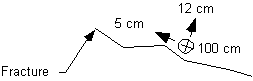
Where the heavy line is the fracture trace on the map. The circle with the x in it is the vertical component (this side down) of the displacement discontinuity vector (and is in this example 100 cm), and the two arrows document the fracture normal and fracture parallel horizontal components of the displacement discontinuity vector.
3) Be sure to quality control your observations. Map broken or disrupted ground and see if its distribution corresponds to broader patterns in the map.
4) Map other landforms and features in the area that may be useful to define the context within which the slide has developed.
Responsibilities and grading:
Individual writeups and drafting
Group summary 1 pager, data, digital compilation (all in electronic format).
75% effort for team subject
25% effort for overall understanding
Questions to address in the write-up (Due February 21 by 5 PM to Arrowsmith)
(should be a total of five pages (~1.5 spaced) plus any figures [which will include your compiled field maps, any other sketches of key relationships that illustrate your points, and a cross-section along the slide, using either the topography from the quad map or other data that I provide]):
An introductory page should address:
1) What is the extent of the slide? What defines it? How is it separated from the unslid material around it?
2) What is the overall sense of motion of the slide? How much deformation occurs along the margins of the slide versus its interior? At what rate do you estimate that the slide is moving? What is the relationship between the slide deformation pattern and topography?
3) What is the relationship between the slide and the rocks in which it is developed? Why is the slide here? What controls the distribution of deformation?
4) What hazard (if any) does this landslide pose to the residents of Black Canyon City? What is your worst case scenario? What is likely? What could be done to mitigate the hazards you have identified?
The remaining 4 pages are dedicated to addressing the questions for your team (see above).