|
HomeArizona EarthquakesPast Earthquakes of NoteEarthquake Information LinksEarthquake Related Research @ ASU
|
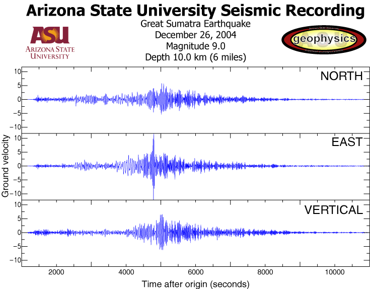
March 02, 2005 Magnitude 4.6 Arizona EventUSGS National Earthquake Information Center page for this eventUSGS location map for this event Did you feel it? - make felt reports and view distribution of felt intensity. February 08, 2004 Magnitude 2.9 and 3.6 events in same location as event aboveUSGS National Earthquake Information Center pages for the:December 26, 2004 Sumatra EarthquakeSeismogram
recorded at ASU (over 15,000km/9,000miles away)! (note the ~150 minute
wavetrain) September 27, 2004 Parkfield EarthquakeHere are a couple of links on the earthquake in Parkfield this morning:http://www.cisn.org/special/evt.04.09.28/ Seismogram recorded at ASU! (pdf format--Thanks to Matt Fouch) Seismogram recorded at ASU! (gif format--Thanks to Matt Fouch) Overview: http://earthquake.usgs.gov/recenteqsww/Quakes/nc51147892.htm Here is a nice map that shows the event and its aftershocks more locally: http://quake.usgs.gov/recenteqs/FaultMaps/120-36.htm Here is an overview on the Parkfield area and the exciting earthquake science being done there: http://quake.usgs.gov/research/parkfield/index.html I have placed a piece of a powerpoint from Nathan Toké that shows what happened in 1857, 1966, and also a couple of pictures of what the place looks like at this location: http://activetectonics.la.asu.edu/Parkfield/parkfieldArrowsmith.ppt Just for comparison with the intensity maps (second plot in the powerpoint), here is the one from today's eq.: http://earthquake.usgs.gov/shakemap/nc/shake/51147892/intensity.html There were moderate earthquakes in 1881, 1901, 1922, 1934, and 1966 at Parkfield that prompted the Parkfield earthquake prediction experiment with a nominal return date of a M6 event of 1985. This event was somewhat different it seems than the 1934 and 1966 events in that its epicenter and I think foreshocks were about 20 km further south than in the past events. The California Integrated Seismic Network says that it was the anticipated event: http://www.cisn.org/special/evt.04.09.28/"> The event triggered some surface creep of a few mm: http://quake.wr.usgs.gov/research/deformation/monitoring/data/pk.creep.7.html. Look here for the map locations: http://quake.wr.usgs.gov/research/deformation/monitoring/pklocations.html#. The magnitude is right at the margin for expected ground rupture. Here are some links from the ASU Active Tectonics' group research at Parkfield: http://activetectonics.la.asu.edu/Parkfield/ Parkfield Unified Visualization Research project |
