GLG410 Computer Project Webpage
Introduction
Click to view
 This study was performed at Wupatki National Monument in Northern Arizona.
Click to see the study area on a map of
Arizona. This study was performed a fault on the southwest side of the
Arrowhead graben, in the east-central part of the study area (outlined in blue). Also
note the location of Flagstaff in the center of the map.
This study was performed at Wupatki National Monument in Northern Arizona.
Click to see the study area on a map of
Arizona. This study was performed a fault on the southwest side of the
Arrowhead graben, in the east-central part of the study area (outlined in blue). Also
note the location of Flagstaff in the center of the map.
To the right you can see the fault scarp at Wupatki National Monument. This scarp is
formed in Early Pleistocene (.89 - 1.1 Ma) Basalt.
We believe that this scarp shows several paleoseismic events. Each of these
events should leave some kind of record on the face of the rock. Because
each seismic event would have suddenly exposed a certain height of rock,
the amount of weathering on the face should change with
height along the face. The hypothesis is that the thickness of the
weathering rind (rock chemically altered by exposure to the elements) is
related to surface age.
The scarp is very sharp, and its morphology suggests that degradation is
primarily by chemical weathering. The scarcity of colluvium at the base
suggests mechanical weathering is a less significant process. Because of
this, we believe that this scarp would be an excellent place to make such a
weathering rind study, since the rinds should be preserved through
time.
Mapping of the face before doing any testing or data-gathering, we
hypothesised several possible events. The youngest event may be represented
at the top of the shelf at the bottom of the scarp, visible in the top
image. Above that, there are more such structures (indents in the face,
possibly due to sub-surface weathering into soil), suggesting
that another event may have occurred between here and the other fairly
likely place, where the scarp goes from being a pretty solid feature to
being cracked and ripped up. At this contact, there was probably an event.
There may also have been another event above this.
This interpretation is shown in the bottom figure. Each line represents the
soil surface before a hypothetical event in the past. As the colours
progress from red to purple, they get progressively older. So the
lowermost event is the youngest. All lines with question marks are
hypothetical, since there is no unequivocal evidence for events at this height.
The two without question marks have some good evidence for events happening
at them.
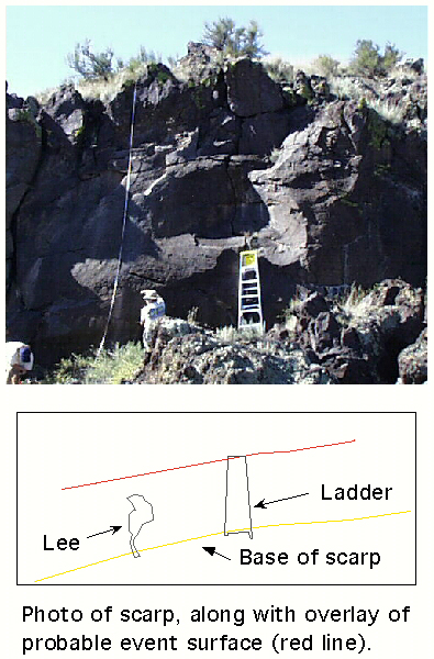
Tracings of Lee and the ladder (~8ft tall) are given for scale. The total
scarp height is approximately seven metres.
Our hope is that the weathering rinds and the patterns they hold will
confirm our hypotheses of the nature of the fault which caused these events,
after which we may be able to date these paleoseismic events. From these
dates we may be able to discover a periodicity of events on this fault,
leading us to estimates of the earthquake hazards in Northern Arizona.
Back to Wupatki project page
Back to Active Tectonics