Fire scars in northeast Scottsdale/Rio Verde area, Maricopa county: initial characterization, 2001
by Ramón Arrowsmith, Department of Geological Sciences, Arizona State University
with contributions from
Mike Ramsey, U. Pitt
Tamara Misner, U. Pitt
Aaron Redman, Rice U.
as a part of:
Multi-Spectral Remote Sensing of Brush Fire Scars in Arid Urban
Regions: Analysis of Future Fire and Flooding Hazards
A project by
Mike Ramsey
and
Ramon Arrowsmith
funded by NASA.
The Image Visualization and Infrared
Spectroscopy (IVIS) Laboratory at the University of Pittsburgh
and the ASU Department of Geological Sciences and Active Tectonics, Quantitative Structural
Geology and Geomorphology group
Summary of principal tasks
We chose the study area because it preserves a number of fire scars in an accessible urban fringe area (Figure 1)..
Main tasks (the web pages illustrating some of them are available from the main ASU page for this project: http://activetectonics.la.asu.edu/Fires_and_Floods/index.html):
- General reconnaisance. This has been ongoing, but now we have a much better understanding of the geography and the fire distributions. This included: Anthem in North Phoenix, Dynamite fire scar, and a tour with Tamara Misner of the Carefree, Dynamite, Pinnacle, and Rio fire scars.
- Collection of spectra from the Carefree fire scar (Winter, 2000 spectra, Photos: Winter, 2000, Summer, 2001)
- Contacting and learning from fire and some land agencies in the area. We met with and have received or are awaiting data from the US Forest Service, Arizona State Lands, and the US BLM. Look at the firenotes for details. McDowell Mountain Regional Park Research Permit request.
- Balloon photography of selected sites along fire scar edges. See Figure 1 for locations of sites on the Carefree fire scar (6/13/01), Carefree fire scar (6/14/01)--good ones, Carefree fire scar (6/14/01); Camp fire scar (10/24/00); Dynamite fire scar (7/24/01); Pinnacle (8/25/01). See Figure 2 for a nice example of the photography of the burn edge along the north portion of the Dynamite fire scar.
- Overflight in light plane to acquire photography of the fire scars. We shot both film and digital camera. Figure 3 shows a nice view of the three main fire scars (Camp, Dynamite, and Rio).
- Topographic surveying of Dynamite fire scar edge: topographic survey location, data, and analysis. Figure 4 shows the topographic map of the site and the delineation of the edge of the fire scar.
- Design and build sediment traps. We have not yet (August 24, 2001) installed them because of permit problems with Maricopa County, but will soon (probably early December). Figure 5 shows a view of one of the bigger traps.
Figures
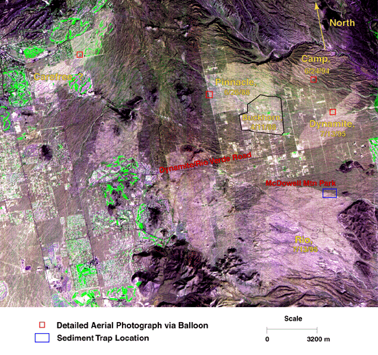
Figure 1. Illustration of fire scars in study area (including date when known), main study sites, and geography overlain on Landsat image.
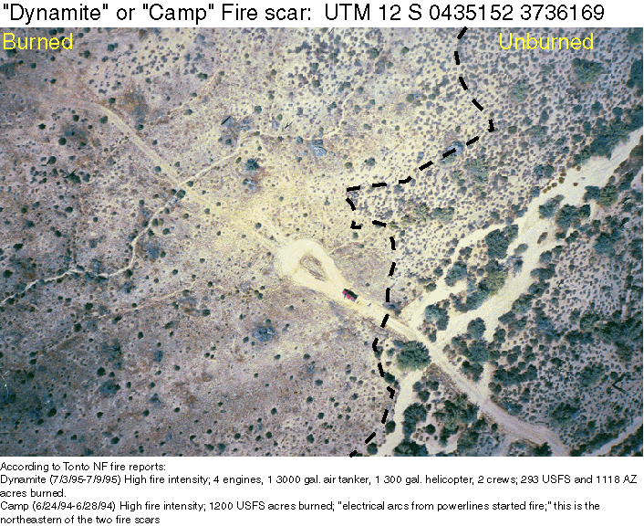
Figure 2. Balloon aerial photograph with annotation depictig the burn edge along the north edge of the Dynamite fire scar. The edge is not sharp, but is transitional with a zone of semi-burned surfaces along the main interface. Based on further consideration of the fire reports, this is the Dynamite fire scar. Note the truck for scale.
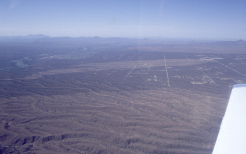
Figure 3. Oblique aerial photograph from light plane looking toward the south over the Camp, Dynamite, and Rio fire scars.
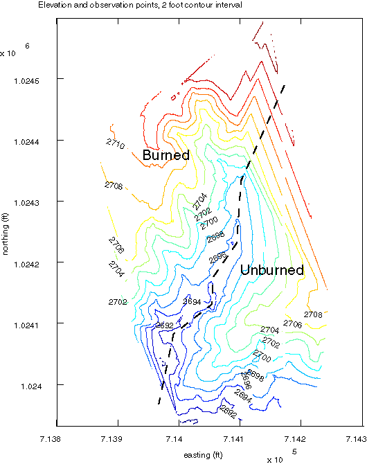
Figure 4. Topographic map of Carefree fire scar edge surveyed using GPS total station. Can you see a difference in the topography?
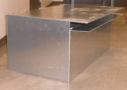
Figure 5. Larger sediment trap (40 cm high, 60 cm wide, 1 m long) built of aluminum by ASU machine shop and Geological Sciences Department staff.
Return to Fires and Floods page
Pages maintained by Ramón Arrowsmith, Department of Geological Sciences, Arizona State University
Last modified August 25, 2001