Data:
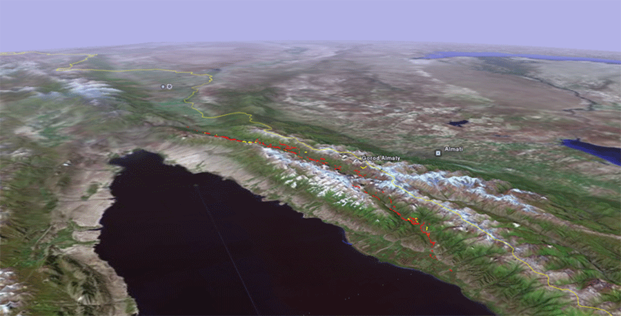
Press:Cooperative Threat Reduction: Getting Further, Faster - Dr. Ramon Arrowsmith and his project on the active tectonics of the Northern Tien Shan was selected by the The Henry L. Stimson Center as an example of the "vital" research being conducted with U.S. Civilian Research and Development Foundation (CRDF) funding.Publications / Presentations:Arrowsmith, et al., Seismotectonics and surface rupture of large intraplate earthquakes: an example from the M7.8 1911 Kebin (Chon-Kemin) earthquake, Northern Tien Shan, Kyrgyzstan, colloquium talk (87 Mb).Crosby, C. J., Arrowsmith, J R., Korjenkov, A. M., Guralnik, B., Mamyrov, E., Povolotskaya, I. E., 2007. The Hunt for Surface Rupture From the 1889 Ms 8.3 Chilik Earthquake, Northern Tien Shan, Kyrgyzstan and Kazakhstan: Eos Trans. AGU, 88 (52), Fall Meet. Suppl., Abstract T23D-1635. (poster is 137 Mb). Arrowsmith, J R., Crosby, C.J., Korjenkov, A.M., Mamyrov, E., Povolotskaya, I.E., 2005, Surface rupture of the 1911 Kebin (Chon-Kemin) earthquake, Northern Tien Shan, Kyrgyzstan, Eos Trans. AGU, 86(52), Fall Meet. Suppl., Abstract T51F-05.
Arrowsmith, J R., Crosby, C. J., Korjenkov, A. M., Mamyrov, E., Povolotskaya, I. E., Surface rupture along the Chon Aksu and Aksu (eastern) segments of the 1911 Kebin (Chon-Kemin) earthquake, Tien Shan, Kyrgyzstan, Eos Trans. AGU, 85 (47), Fall Meet Suppl., Abstract T14C-02, 2004.
Papers by our Kyrgyzian colleagues:ANDREY KORJENKOV, KARL BAIPAKOV, CLAUDIA CHANG,YURY PESHKOV & TAMARA SAVELIEVA, Traces of Ancient Earthquakes in Medieval Cities Along the Silk Road, Northern Tien Shan and Dzhungaria, Turkish J. Earth Sci., Vol. 12, 2003, pp. 241-261.Andrey M. Korjenkov, Vitaly A. Kovalenko, Salavat F. Usmanov, 2002, Long-Term Preservation of Paleoseismic Deformations as a Tool for Revealing Traces of Ancient Seismic Catastrophes (On Example of the Chon-Kemin Valley, Kyrghyzstan), 7th International Symposium on High Mountain Remote Sensing Cartography, ICA 2002. Andrey M. Korjenkov, E. Mamyrov, M. Omuraliev, V. A. Kovalenko, S. F. Usmanov, 2002, Rock Avalanches and Landslides Formed in Result of Strong Suusamyr (1992, M = 7,4) Earthquake in the Northern Tien Shan - Test Structures for Mapping of Paleoseismic Deformations by Satellite Images, 7th International Symposium on High Mountain Remote Sensing Cartography, ICA 2002. Dan Bowman, Andrey Korjenkov, Naomi Porat, Late-Pleistocene seismites from Lake Issyk-Kul,the Tien Shan range, Kyrghyzstan, Sedimentary Geology 163 (2004) 211–228 Dan Bowman, Andrey Korjenkov, Naomi Porat, Birka Czassny, Morphological response to Quaternary deformation at an intermontane basin piedmont, the northern Tien Shan, Kyrghyzstan, Geomorphology 63 (2004) 1–24 Full list of publications and conference presentations resulting from this project. Links:1911, Ms 8.2 Kemin earthquake - Summary of the 1911 EQ by Dr. Damien Delvaux |
|
This research is funded by a grant from the U.S. Civilian Research & Development Foundation (CRDF) |
