NEW: Structural Geology, Tectonic Geomorphology, and Recent Slip History of the South-Central San Andreas Fault
--Geological Society of America 2007 talk by Arrowsmith
Parkfield Home
Paleoseismology and Geomorphology
Geologic Mapping and Structural Synthesis
3D Data Integration and Visualization
September 28, 2004 Parkfield Earthquake
Project Publications
Data, Resources and Links
![]()

|
These pages are devoted to our ongoing research related to the Geology and Geomorphology of the San Andreas Fault near Parkfield, CA. This work is focused on characterizing the kilometer-scale geometry of rock bodies and structures and their motions
along the San Andreas Fault (SAF) in the vicinity of Parkfield, California. We are working to determine the positions, attitudes, and characteristics of the major rock bodies along the SAF, and to determine the rates of deformation associated with the principal structures of the fault zone. We are concerned with time scales long enough to define the active
deformation sources, but short enough that they have not significantly evolved (Late Quaternary). The data that results from our studies are useful for fundamental studies of fault zone structure, rupture interactions with shallow heterogeneity and fault
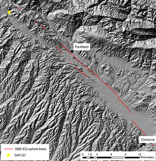
zone anisotropy, fault mechanics, and applied studies of earthquake hazard for south-central California. In addition, our studies provide important framework information for existing and proposed geophysical and drilling investigations (San Andreas Fault Zone Observatory at Depth (SAFOD)).
Our studies can inform the engineering and drilling effort as well as enhance the interpretations of the coring and measurement projects by providing detailed geological and geomorphic maps and data, and geometric and kinematic models for the SAF at Parkfield.
The pages linked from the navigation bar at left will take you to more information on the various components of this project. |
| This project is supported by the US National Science Foundation Project EAR-0310357 and by the US Geological Survey Educational Mapping program. |
