Parkfield Home
Paleoseismology and Geomorphology
Geologic Mapping and Structural Synthesis
3D Data Integration and Visualization
September 28, 2004 Parkfield Earthquake
Project Publications
Data, Resources and Links
![]()

|
SUMMARY: The Parkfield segment of the San Andreas Fault (SAF) is the transition zone between the creep-dominated segment of the SAF to the northwest and the locked segment to the southeast. Geodetic studies indicate ~10 mm/year of the SAF 35 mm/year slip-rate is accommodated by creep at shallow depths of the SAF near Carr Hill, suggesting the remaining slip may occur in moderate to large earthquakes. Foreshock intensities of the 1857 M7.8 Fort Tejon earthquake were similar to 20th century Parkfield events, suggesting that the 1857 event may have nucleated in the Parkfield area. Paleoseismic investigations near Parkfield have achieved limited success in exposing useful fault zone stratigraphy. Our goals were to investigate the style and timing of late Pleistocene and Holocene faulting along this segment of the SAF. Specifically, did the 1857 or similar large prehistoric earthquakes rupture through the Parkfield segment? In addition, is it possible to distinguish deformation caused by these large magnitude earthquakes from deformation associated with the moderate 1966-style earthquakes and aseismic creep? This work is being conducted by Nathan Toké for his M.S. thesis. During the summer of 2004 an intensive paleoseismic trenching project was undertaken just south of the Parkfield bridge. Two fault-perpendicular excavations were cut in a late Pleistocene fluvial terrace of Little Cholame Creek just north-northeast of Carr Hill. The first excavation (Miller sag trench (MST)) crossed a sag pond formed by a small right step in the fault trace. The second trench (Phoebe's Trench (PT)) was a bit further south and crossed a small pressure ridge. FIGURES: The figures below illustrate the relationships exposed in the Miller Sag excavation: 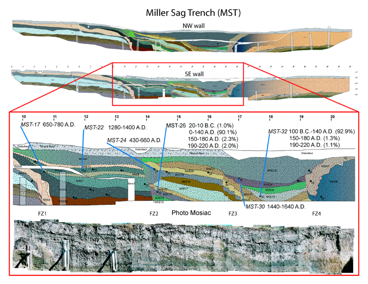 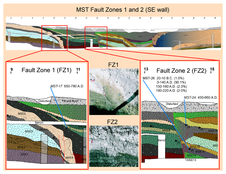  Phoebe's Trench: 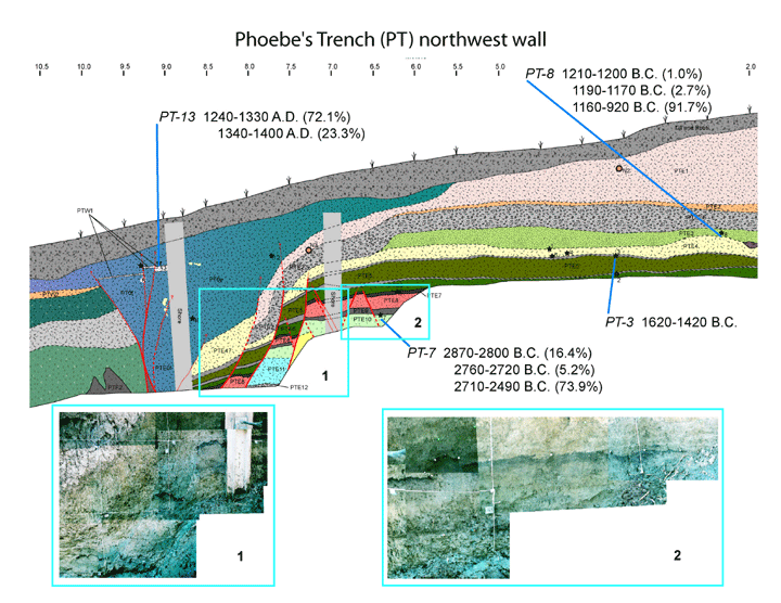 The fortuitous occurance of the September 2004 M 6.0 earthquake a matter of months after we completed our excavations offers the unique opportunity to compare paleoseismic trenching results with the actual ground fracturing that occured during this characteristic Parkfield earthquake. In order to aid our interpretation, we performed a high-resolution total station survey of the ground fractures through the paleoseismic study site. For more information on the 2004 earthquake please visit out September 28, 2004 Parkfield Earthquake page. The figure below summarizes our post-EQ mapping and the realtionship between our excavations and the fractures: 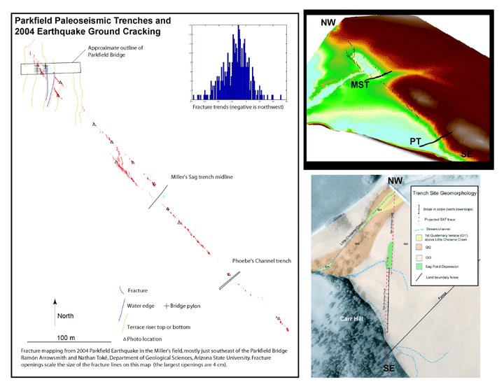 ABSTRACTS:
Toké, N. A., Arrowsmith, J R., Crosby, C. J., Young, J. J., Preliminary paleoseismology results from the Parkfield, CA Segment of the San Andreas Fault, Southern California Earthquake Center Annual Meeting, Proceedings and Abstracts, v. 14, Palm Springs, CA, September, 2004 |
